Workout Loops
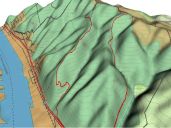
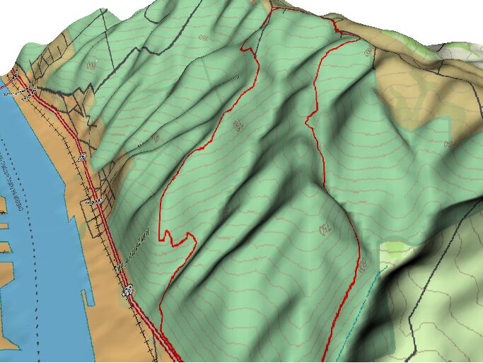
These are loops primarily at the Northwest end of Forest Park. They make for good workouts, and have nice scenery. The two pictures below are looking south/southwest from the river, as Forest Park covers the north side of the Tualatin Mountains. They are presented in the same ratio so the differences in the amount of climbing is apparent (the topo line intervals are 50 feet). Click on the pictures for a closer look.
Saltzman/Firelane 3
Climbing: Easy
Start at the gate at Thurman, Take Leif Erikson to Saltzman, climb up Saltzman to Skyline. Go left on Skyline and ride on the road for about 1-2 miles, past the cemetary. You'll pass three brick gates on the left, the third one being Thunder Crest (there is a big house with a copper roof at the entrance). About 100 feet into the neighborhood (on the right) is the top of fire lane 3. Have a blast going down firelane 3 and then make a right onto Leif Erikson which will take you back to the entrance. There are also many other ways to get up to Skyline and back down to Leif Erickson.
Firelane 10/Springville
Climbing: Moderate
Parking at the Springville lot, head west on Skyline for 1.4 miles, passing through the Germantown intersection to Newton Rd (Dead End sign on the right). Ride down Newton Rd to the parking lot. On the west side is Newton (fireroad), on the east side is Firelane 10. Take Firelane 10 - this will take you down and up to Germantown. Ride downhill on Germantown for a short distance until you see the big Leif Erikson lot on the east side of the road. Take Leif Erikson for a few miles, to the first large 4-way fireroad intersection; this is Springville. Ride up Springville (approx 1 mile), and you'll be back at your vehicle. For a tougher ride, do this in the opposite direction. As you can see on the bottom right side of this picture, Firelane 10 has a big climb there (though its not really that straight up - the GPS gets a little flaky on the northwest side these hills).
Firelanes 15/12/Newton
Climbing: Hard
Parking at Newton Rd, ride back up to Skyline, then 1 mile west to BPA Road (30 yards past the power lines, next to fire hydrant on right), or 1/2 mile further to Firelane 15. If you take BPA, you should peel off to the left onto Firelane 12 about 1.5 miles from the trailhead - be careful, its easy to miss (if you've reached the summit, you just passed it!). BPA heads straight down, and makes for a quick but uninteresting downhill. Firelanes 12 and 15 intersect; head south (downhill) to Hwy 30. East on Hwy 30 for 300 yards to the trailhead. Just past the trailhead, Newton is on the left and BPA is on the right. BPA heads straight up from 30 to the top of the hill, and climbs over 800ft in much less than a mile - a gut-wrenching climb. The bottom half of Newton is a very tough climb, particularly when its damp (notice the lines on the bottom left of the map!).